07/26/07 - Driving Time and Distance Map of the North Olympic Peninsula

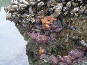
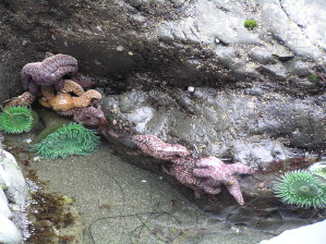
We get a number of questions from people trying to plan trips to the North Olympic Peninsula and not sure of how far it is from one attraction to another. Olympic National Park is a big park comprising the central part of the peninsula and much of the Pacific Coast. There are no roads through the middle of the park, and there is no long coastal road to follow. This makes planning a trip a bit tricky. Even getting from La Push to Rialto Beach, a distance of perhaps a mile or two along the coast requires driving inland to the bridge at Mora, so the total drive is perhaps 11 miles and takes about 25 minutes. Hurricane Ridge is not very far from the Hoh Ranger Station as the raven flies, but it is several hours drive.

To help the many visitors to the park and surrounding areas, we offer this Kaleberg Driving Time and Distance Map of the North Olympic Peninsula. It is based on the distances as computed by Google Maps, but we have used our own estimated driving times rather than the Google estimates. Google has some peculiar ideas on how fast one can drive on various park roads, and they still have the Hurricane Hill Trail from Whiskey Bend to Hurricane Hill as an automobile road! We're sure that was a trail, even before Google was founded. We've also taken some liberties in defining certain intermediate locations which do not appear on any map. In general, things like Elwha Turnoff and Hoh River Crossing are not marked as such on any other map you might find, but are useful junction points linking roads and turnoffs, just what you want for planning your drive.


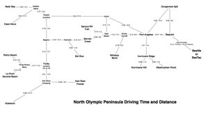
Driving Distance Time Map for the North Olympic Peninsula

Keywords: maps, science, port angeles, hurricane ridge, hurricane hill, hoh rain forest, elwha, la push, lake crescent, obstruction point, rialto beach, la push, spruce railroad


04/10/06 - New Tide Tables for Hikers

We've updated the tide tables for Cape Alava, La Push (Mora and Third Beach) and for the Dungeness Spit. We're trying out a new display format with less irrelevant cruft, and the good hiking days marked out in green.


Keywords: tides, cape alava, la push, dungeness spit, dungeness


The Cave at Second Beach

07/01/05 - Solstice Tides

Thanks to the solstice, there have been some very low tides out at the West End beaches. This includes our favorite beach, Second Beach. At the south end of the beach there is a small cave that you usually cannot even get to at high tide. At low tide, the entrance is accessible from the beach. We went on a day with a particularly low tide, as you can see on the left, with only 0.8 feet of water. (If you want to plan your own low tide visit, check out our Tide Finder program, or our tide table for La Push).

Aside from being able to explore various caves, the low tide also brought up a lot of starfish. You can see them bunched up near the waterline on a mussel rock. We have never seen so many starfish stacked together like plastic toys. We could also see a lot more anemones, and not just the dull sand covered ones, but lovely blue-green ones, in the shallow tidal water. We only saw one eagle, but we were quite impressed with Second Beach nevertheless.
Seastacks at Second BeachHuge Number of StarfishBlue Anemones

Keywords: tides, second beach, beaches, la push, software


01/05/05 - Sunset at Second Beach

Do we have great sunsets around here or what?

We were out at Second Beach near La Push and couldn't help noticing a rather pretty sunset. The sea stacks, in silhouette, were pretty neat too.
Second Beach Sunset

Keywords: second beach, beaches, atmosphere, la push