The Dungeness Spit is one of those strange geographical features that one tends to read about in books, but rarely encounters in the real world. It is a long, stable sand spit, jutting out into the Strait of San Juan de Fuca. It may change slightly from year to year, but over all, it remains the same. It offers a 4.5 mile beach hike, away from the mainland, and out into the sea. Along the way to the lighthouse, there is sand, sea, and tons of driftwood. There is also wildlife: sea birds, seals, and eagles. You can take the entire hike or just a little bit of it.
Take 101 east from Port Angeles and watch for Kitchen-Dick Road on your left. There is a left turn lane. Use it and make the left turn. Follow Kitchen-Dick Road north until it ends with a right turn onto Lotzegel Road. The next left after this right is the entrance to the Dungeness Spit Reserve. Drive down to the trailhead parking lot.
NOTE ON TIDES: It is a good
idea to check the tide table
since the hike is much easier at low tide. We also have an iCal calendar with good tides
for hiking the spit marked on it.
This is one of the more popular sites in the area, so it gets pretty crowded on sunny summer weekends, so come early. The trail starts with the friendly rangers who give out maps and warn you about the closed area on the inside of the spit. This is mainly marshland and is strictly for the birds.
From the parking lot, the trail descends towards the spit, passing through a pleasant enough wooded area, but when you get to the bluff is when things start getting interesting. From the observation area, the spit lies in its glory before you. Take a moment to admire it, because you will be entering another world.
Take the trail downward, past the "The Brant - A Goose With Problems" informational display, and step out onto the beach. The bluffs tower over you here. They are your last link with the mainland.
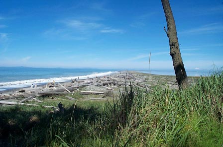
Follow the trail onward. The crowds quickly thin out and the bluffs seem small and far away. Now it is just you and the sea, the sand and the driftwood. The sea, the sand, the driftwood and the kelp, and the plovers, and the gulls, the loons, the eagles, and the seals.
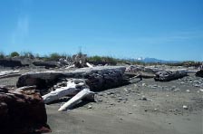
The scenery seems to stay the same, even as it changes. Exotic driftwood shapes line the beach above the high tide mark. The kelp washes in and out with the tides. Towards the three mile mark, the beach starts to turn and the bluffs behind you vanish. The mainland is gone.
Keep going. Out here is where you will find the eagles. Watch for them flying or perched on the taller pieces of driftwood. Here is also where you will find the seals, especially past the four mile point, as you approach the lighthouse. On clear days you can see the cloud-like form of Mount Baker floating eerily before you.
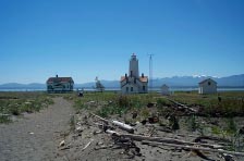
The lighthouse itself, 4.5 miles from the bluffs, about 5 miles from the parking lot, is surprisingly domestic with its living quarters and outbuildings. You can drop in for a visit, or head on for a bit, to the end of the spit. We usually turn back and find a nice place to stop and picnic, before heading back.


© Copyright Kaleberg Symbionts 2002-2006