Second Beach
UPDATE - 15 April 2007- Second Beach is OPEN. While there is no official agreement yet, the local Quillayute tribe feels that they are close enough to reopen the beach for the tourist season. This is great news. It means that one of our favorite beaches is being reopened, and that the Quillayute will have somewhere to go in the event of a tsunami. Since this is a local matter, there is not all that much in the media, but check out this KNDO/KNDU/AP article and this Peninsula Daily News background piece and update.
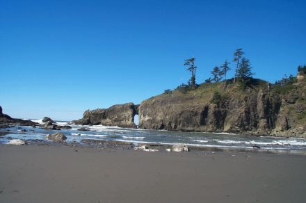
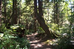
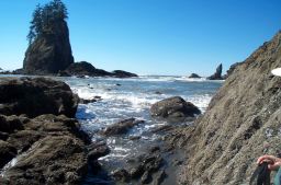
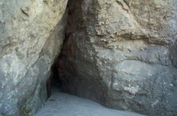
Second Beach is one of a series of three beaches along the road to La Push. Unlike Rialto Beach, getting to Second Beach has the added drama of a forest walk through ferns and cedars, first up hill and then down the canyon to the open beach. It is like coming outdoors when you arrive at the sea, a wonderfully dramatic effect. Unlike Cape Alava, the hike to the beach is short, a bit less than a mile, so you can still get back to Bella Italia for dinner. In addition to the forest walk, Second Beach offers wild rock formations, a broad open beach, gloriously twisted driftwood, tidepools, beach streams and a little cave to explore at low tide.
How to Get There
Head west from Port Angeles on route 101 and continue past Sappho. Before you get to Forks, keep your eyes open for the signs to route 110 to La Push. The turn is right after the Smokehouse Restaurant. Follow the road west and go past the little restaurant and general store on your right. They have good espresso and excellent blackberry pie here, but you want to stay on the road to La Push. After another four or five miles, start watching for the Second Beach parking lot on your left.
 The Kaleberg Hike
- Second Beach - 4 stars - great beach for explorers; offers rain forest and the sea
Second Beach
This hike starts with a stunning .7 mile walk through a rainforest to a magnificent sandy beach. You take the trail from the parking lot and head upward for a ways. The trail actually starts outside the National Park boundary, but there is no dramatic change in conditions when you enter the park. The trees are tall and twisted, the foliage emerald green. After an easy 100' climb, the trail descends nearly 200' to the beach, nestled in the arms of a canyon, which gives you a good sense of how tall the trees are, and how sheletered the forest is, compared with the open beach.
On the beach, you can head north to explore the tide pools and check out the wave carved tunnel, or you can head south and look for the little cave down towards the end of the beach. There are sea stacks and warped rock formations up and down the coast. All you have to do is wander and wonder.
Kaleberg Hints
- Check the tides, you can get trapped at the south end of the beach if the tides are rolling in.


© Copyright Kaleberg Symbionts 2005